-
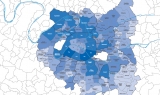
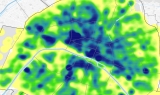
 Map
MapPopulation density
May 2019 -
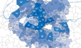
 Map
MapEmployment density
May 2019 -
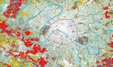 Map
MapThe 3 vegetation strata
May 2019 -
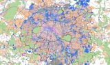 Map
MapDiversity: Businesses / Housing
May 2019 -
 Map
MapSocial housing applications
May 2019 -
 Map
MapTypes of housing on each land plot
May 2019 -
 Map
MapPhysical land occupation
May 2019 -
 Map
MapLocal Energy Plan
May 2019 -
 Map
MapAvailable accommodation places, appropriate housing and rental intermediation
May 2019 -
 Map
MapCommercial density in 2017
May 2019 -
 Map
MapUpdate on raw-water resources
May 2019 -
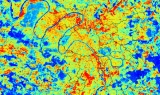 Map
MapSummer thermography
May 2019 -
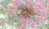 Map
MapUrban fabrics
May 2019 -
 Map
MapHeritage - Constructions protected by the state
May 2019 -
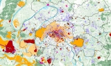
 Map
MapProjects for the urban and transport development in the 16 station neighbourhoods of the Grand Paris Express line 15 south
May 2019
Our works
Find here all Apur’s productions, Studies, Notes, Summary Reports, Datavisualisations, etc.
Your search
111 results