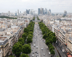
The major road running east-west which starts at the Tuileries, goes through Neuilly-sur-Seine and La Défense and carries on towards Nanterre and the Seine, is a feature which is inseperable from the identity and history of the metropolis. It plays a real role in the larger landscape as well as in the economy.
However, the middle section, the Pont Neuilly, Avenue Charles de Gaulle, Porte Maillot and the Avenue of the Grand Armée stands out as less attractive, forming a break in its continuity. The projects underway or in preparation are focusing with renewed intensity on the issues affecting the historic axis with regard to the metropolis as well as the territories it crosses.
The present study is based on a shared diagnostic and has identified the urban problems affecting the central section of the historic axis: large landscape, public space, transformable spaces.
This study has been carried out by Apur together with the City of Paris and the Regional Prefecture (DRIEA), members of Apur’s Board of Directors and, within the framework of a partnership supported by a study grant agreement, with Hauts-de-Seine Regional Council (CG92), Neuilly-sur-Seine City Council, the La Défense Seine Arche Public Development Organisation (EPADESA), and the Paris Chamber of Commerce and Industry (CCIP).
