Inter-communalities in Ile-de-France

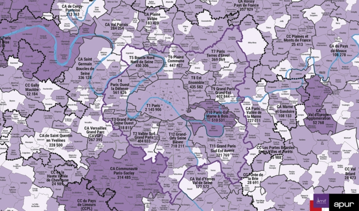
Map of intercommunalities in Ile-de-France © Apur - Amif

For more than 10 years, Apur has been developing, in conjunction with the Association of Mayors of France (Amif), a map of intercommunalities in Ile-de-France. This map indicates for each intercommunity the municipalities that make it up and the number of inhabitants it brings together.

Resources

Documents to download

  • Map

    2023 map of municipalities and intermunicipalities in Île-de-France that are members of Amif

    Format : pdf, 6.4 MB
    Download
  • Map

    Map of inter-communalities in Ile-de-France - 2022

    Format : pdf, 3.59 MB
    Download
  • Map

    Map of inter-communalities in Ile-de-France - 2020

    Format : pdf, 3.45 MB
    Download
  • Map

    Map of inter-communalities in Ile-de-France - 2017

    Format : pdf, 4.97 MB
    Download
  • Map

    Map of inter-communalities in Ile-de-France - 2016

    Format : pdf, 4.26 MB
    Download
  • Map

    Map of inter-communalities in Ile-de-France - 2015

    Format : pdf, 3.3 MB
    Download
  • Map

    Map of inter-communalities in Ile-de-France - 2014

    Format : pdf, 2.83 MB
    Download
  • Map

    Map of inter-communalities in Ile-de-France - 2013

    Format : pdf, 2.32 MB
    Download
  • Map

    Map of inter-communalities in Ile-de-France - 2012

    Format : pdf, 8.89 MB
    Download
  • Map

    Map of inter-communalities in Ile-de-France - 2011

    Format : pdf, 1.87 MB
    Download
  • Map

    Map of inter-communalities in Ile-de-France - 2010

    Format : pdf, 831.53 KB
    Download